
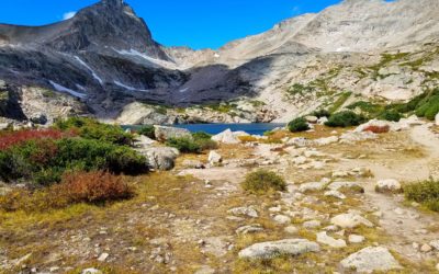
Mitchell and Blue Lake (11,360′), Front Range
Mitchell and Blue Lake are located in the Brainard Lake Recreation Area, west of Boulder, Colorado. Brainard Lake itself is a small lake at the junction of two major valleys in the east central Indian Peaks Wilderness. The northern of the two valleys holds Mitchell and Blue Lakes, while the southern valley holds Long Lake and Lake Isabelle.
Mt Audubon (13,223′) is another example of the beautiful trails located in the park.
Trail Stats
- Trailhead: Mitchell Lake Trailhead
- Round trip: Mitchell Lake 2 mile/ 3.2 km (10,650′)
- Blue Lake 6 miles / 9.7 km
- Elevation: 10,525′-11,360′ / 3,208 m – 3,462 m
- County: Boulder
- Agency: U.S. Forest Service
- Nat’l Forest: Roosevelt
- Nat’l Wilderness: Indian Peaks
Weather
GPS Route with Elevation
Trail Pictures
Tried the Mt Audubon trail first, but wind would be to strong to summit Mt Audubon
Video Tour
Trail Directions
The wooded trail enters the Indian Peaks Wilderness near the Mitchell Creek bridge. It continues to Mitchell Lake, crossing a second bridge over the inlet. From the lake you can see Mt Audubon across the water. Another 2 miles of trail climb more steeply, following the creek into an open valley to Blue Lake. This lake lies at tree line below Mount Toll, a cone-shaped pinnacle on the Continental Divide.
Trailhead Directions